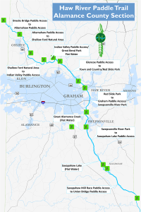
Haw River Paddle Trail
 The Haw River begins near the Haw River State Park, just north of Greensboro. The water trail is first accessible to paddlers at Brooks Bridge near Gibsonville. The water trail continues through Alamance County and finally connects Jordan Lake in Chatham County. Shallow rocky sections of the river create excellent rapids for paddling. In addition to a water trail, the Haw River Land Trail currently consists of just over 20 miles of land trails following along the Haw River and overlapping with the Mountains-to-Sea Trail. Check out our listings below to plan your trip! You can also check out the Haw River Trail Association for more information.
| Access | Address | Miles to Next | Hours to Next |
| 01) Brooks Bridge | 7403 Brooks Bridge Rd, Gibsonville, NC 27249 | 4.1 | 2.5 |
| 02) Altamahaw | 2996 North NC Hwy 87, Elon, NC 27244 | 2.8 | 2.0 |
| 03) Shallow Ford Natural Area | 1955 Gerringer Mill Rd, Elon, NC 27244 | 4.0 | 2.0 |
| 04) Indian River | 930 Indian Valley Dr, Burlington, NC 27217 | 0.9 | 1.0 |
| 05) Great Bend Park | 350 Greenwood Dr, Burlington, NC 27217 | 0.4 | 0.5 |
| 06) Glencoe | 2348 Glencoe St, Burlington, NC 27217 | 3.6 | 2.0 |
| 07) Town and Country Park | 2999 Regent Park Ln, Burlington, NC 27217 | 1.1 | 1.0 |
| 08) Red Slide Park | 389 Lang St, Haw River, NC 27258 | 3.3 | 3.5 |
| 09) Graham Paddle Access | 1124 Cooper Rd, Graham, NC 27253 | 1.9 | 1.5 |
| 10) Swepsonville River Park | 2472 Boywood Rd, Swepsonville, NC 27253 | 5.5 | 3.0 |
| 11) Saxapahaw Lake | 6096 Jordan Dr, Graham, NC 27253 | 5.6 | 2.5 |
| 12) Union Bridge | 7525 Greensboro-Chapel Hill Rd, Chapel Hill, NC 27253 | 5.5 | 3.0 |
| 13) 15-501 | 4551 US Hwy 15 501 N, Pittsboro, NC 27312 | 12.0 | 6.0 |
| 14) Haw River Canoe Launch | 348 River Access Rd, Pittsboro, NC 27312 | 4.0 | 2.5 |